Marsh River Preserve
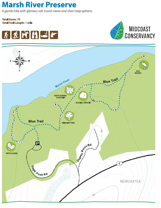
The 70-acre Marsh River Preserve located in Newcastle protects over a mile of frontage along the ecologically significant Marsh River. Approximately one mile of trail winds through mixed forests and meanders along beautiful salt marshes offering views across the Marsh River. An interpretive guide provides information about the ecology, history and geology of the area.
Story of the Land
Marsh River Preserve protects 5,500 feet of frontage along Marsh River. The trail meanders along beautiful salt marshes and offers stunning water views.
In 2003, as part of the Land for Maine's Future Program's River~Link project, the SheepscotValley Conservation Association, now part of Midcoast Conservancy, purchased the remaining lots of a failed subdivision on the Marsh River through a major fund raising effort. The preserve was created to protect the marsh and forested upland along the Marsh River from development. At the eastern end of the trail, you can see that Marsh River splits into Deer Meadow Brook and the confluence of waters that flow into Sherman Marsh. In 2005, the salt marsh you see now was a freshwater lake of more than 200 acres. Sherman Lake, as it was called, was created in the 1930s when a dam was built to allow Route 1 to cross Marsh River. Even when the road was moved in the 1960s, the dam and lake remained in place, until a storm surge wiped out the dam in 2005 and completely drained the lake.
Less than a year later, the Maine Department of Transportation allowed the drained area to return to its natural state, the salt marsh you see today.
Marsh River Preserve was protected with assistance from Land for Maine's Future, Maine Coast Heritage Trust, North American Wetlands Act, Davis Foundation, Maine Wildlife Habitat Initiative, Fields Pond Foundation, Sears-Swetland Foundation, and the Land Trust Alliance.
What you Might See
The trail leads to exquisite views of the Marsh River where you may notice the salt marshes, one of the most important natural resources and most productive habitats on earth! Salt marshes are nature's filtration systems and act as giant sponges, cleaning the water and controlling flooding. They are great places to fish, boat and bird watch. Look for great blue herons, Northern harriers, ospreys and several species of ducks here.
Two-thirds of our commercial fish, shellfish and bait species (including striped bass, bluefish, clams, lobster and sandworms) depend on salt marshes at some point in their lifecycle.
Along the trail, notice how the forest changes from one area to the next. Mature hemlocks are dominant along the cooler north-facing slopes and seeps (wet areas on hillsides) of the main trail, while beech and other hardwoods are found along the smaller loop trails. You may see witch hazel in forest openings and glacial erratics in the cooler hemlock forest with moss and ferns. Also look for pileated woodpeckers and the rattlesnake plantain (a native orchid) found along the trails!
Directions:
Marsh River Preserve
Eagle Point Rd.
Newcastle, ME 04553
Directions: From Wiscasset take Rt.1 North for 4.5 miles and turn left onto Osprey Point Road. Bear left onto Eagle Point Road and follow to cul-de-sac and park. From the North, take Rt. 1 South into Newcastle and take a right onto Osprey Point Road which is just past the Sherman Lake Rest Area. Bear left onto Eagle Point Road, follow to cul-de-sac and park

